
STUDYING. PEARLAND. OVER. TIME.
On The SPOT
Pearland's Founding
This section of the website will focus on how Pearland came to be known as "Pear-Land."
Santa Fe Railroad
By 1875, the city of Houston had a five-figure population despite periodic outbreaks of yellow fever and other diseases. By the census of 1880, Galveston had fifteen thousand residents.
The Gulf, Colorado, and Santa Fe Railroad built a sliding switch called "Mark Belt" as part of its Houston to Alvin branch rail line. A sliding switch was a place where trains could stop to load cattle, supplies, or crops. While for many years there was uncertainty and confusion on the topic, there is now a consensus among historians that Mark Belt is named for Marcus Lindsey Belt. He was the Superintendent for The Brazoria Land and Cattle Company, which owned grazing land from Liverpool to Clear Creek from the 1870s to 1890s. During this time, there were not many residents in the area, so it was named for Mark Belt because he was connected to the land. When a post office opened in 1893, the settlement also used the name Mark Belt. Mark Belt eventually moved back to Missouri.
As the rail line grew, the need for a depot became apparent. The depot was not built by the railroad company but rather the Southern Homestead Company. The depot became part of the railroad system because the Gulf Colorado and Santa Fe Railroad ran the trains that stopped there. The depot became a place where people could pick up mail and greet visitors. Locally produced cotton, hay, cattle, and fruits and vegetables were shipped to the market by the railroad from the depot. Since there were little to no cars during this time in Pearland's history, the depot became an an important place in Pearland.
The railroad's arrival in 1882 was important to the community because railroads could connect rural areas to larger urban centers. It facilitated transport of both the goods that farmers and ranchers sent to market and the people migrating to and from the area.

Image Credit - Pearland Historical Society
Image of Marcus Lindsey Belt

Image Credit - Pete Hughes
Image of Pearland's Santa Fe Railroad Depot

Image Credit - Pete Hughes
Image of the Pearland and the Santa Fe Railroad Historical Marker

Image Credit - Pete Hughes
Image of Pearland's Santa Fe Railroad train car
Wilhelm Zychlinski
Captain Wilhelm Zychlinski had a very pivotal role in Pearland's history during the short time he was in the area. He was referred to by multiple names/titles, such as William Zychlinski and Count Witold von Zychlinski. Zychlinski came to Pearland in 1892, where he purchased around 2,560 acres near Mark Belt. The North South Railroad line ran through Zychlinski's property, near present day Galveston Avenue and Main Street. This intersection remains one of Pearland's most historically significant locations. Once he acquired the land, Zychlinski had it surveyed and subdivided. Zychlinski did not personally file the plot. Instead, his attorney, J. W. O'Brian filed the map with the county Hall of Records on September 26, 1894. Filing this map officially created Pearland as a town. His attorney filed an official plot with Brazoria County that divided the acreage into town lots, blocks, and streets. Zychlinski's filed streets are still visible today: Walnut Street, Pear Street, Broadway Street, Jasmine Street, Plum Street, Orange Street, Magnolia Street, and Oak Street. These were some of the east-west roads in his filed plat. By purchasing land by the railroad, he ensured that the town would have access to transportation. His land purchase accelerated land development in the area. He named the townsite "Pear-Land" due to the flowering pear trees in the area, but the hyphen was shortly dropped. His later life after leaving Pearland is a mystery.
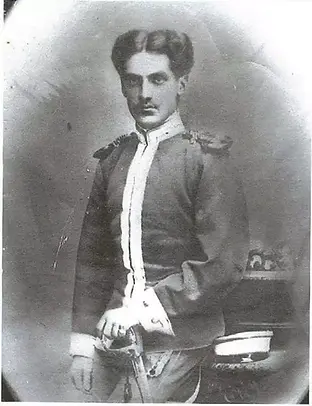
Image Credit - Pearland Historical Society
Image of Captain Wilhelm Zychlinski

Image Credit - Pearland Historical Society
Image of Mayor Emeritus Tom Reid Standing Next to the Zychlinski Park Historical Marker
Southern Homestead Company
President of the Southern Homestead Company, S. M. Christensen moved his family into a custom-built two-story home in Pearland. His role was that of a land developer and an early real-estate promoter of Pearland.
Southern Homestead Company advertised in newspapers in the Midwest using fertile soil and fruit trees such as the pear tree to attract farmers to the area they called a "garden paradise." The settlers came by rail and covered wagons. By attracting settlers and building infrastructure, the company helped support early businesses and farms in the area.
Early Settlers
During this period, the Hunters and Martins became a part of the Pearland community. Dr Johnson Calhoun Hunter, a member of the Austin Old Three Hundred, started a plantation in the 1820s. Robert Lee Hunter was born to Josephine Bonaparte Estes and Thomas Johnson Hunter on November 16, 1868 on Dr. Hunter's Plantation. Around 1903, Hunter sold his plantation holdings and moved to be near his sister, Eunice, and to join her husband William T. "Billy" Magee, a successful rancher and fellow influential Pearlander, in the cattle business.
Julia Iva Martin, who would eventually marry Robert L. Hunter, was born in Red Cloud, Nebraska on May 15, 1883 to Elmira Monselle [Munsell] Martin and Samuel Pleasant Martin. The Martins came to Texas in 1894 and settled in Mark Belt (Pearland). She married Robert Hunter on September 27, 1905 and, from 1906 to 1919, they had four children. The family resided in a home on Orange Street, one of the original streets in Zychlinski's plot. The Hunters were renown and respected in Pearland and, according to one of their daughters, regularly offered advice and hospitality to former slaves. Robert Lee Hunter died in the old Hunter house on January 18, 1941 and Julia Iva Martin Hunter did in Houston on May 6, 1970. Both are buried in South Park Cemetery. Descendants of the two families still lived in Pearland.

Image Credit - Pearland Historical Society
Image Credit - Pete Hughes
Image of Pete Hughes and Brenda Martin Riggs, a descendent of Samuel Pleasant Martin


Image Credit - Pete Hughes
Image of the Robert L. and Julia Martin Hunter Historical Marker
Developments before the Storm of 1900
A compact business district formed at the intersection of Main (Telephone Road) and Broadway (FM 518). The business district featured a hardware store, a general store, a lumber yard, a printing office, which published The Pearland Advocate, and a hotel.
A single church was shared by the Methodists, the most numerous denomination in Pearland at the time, the Baptists, the Presbyterians, and the Church of the Brethren. The Church of the Brethren were known as the Dunkers because of their practice of triple-immersion baptism.
The community had a four-room, wooden schoolhouse with an enrollment of 100 and a faculty of four. The school was built and run entirely from local parent contributions.
By this time, Pearland had a population of roughly 400. However, they did not know what they would experience in 1900.
